
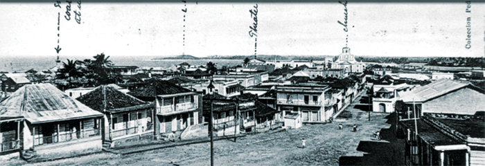
[ Vista de calle en Ponce ]
Title
[ Vista de calle en Ponce ]
Subject
Streets
Street
Street scenes
Street scene
Street
Street scenes
Street scene
Description
Ponce 1881
"Ponce, major city and principal port of southern Puerto Rico. The third most populous urban centre of the island, after San Juan and Bayamón, the city is situated 3 miles (5 km) north of its port, Playa de Ponce. Founded in either 1670 or 1680 as Nuestra Señora de Guadalupe de Ponce, it was raised to the status of town in 1692, villa in 1848, and city in 1877. In 1897 Spain’s overseas minister designated Ponce as the capital of the southern region, one of the island’s two major districts. In 1898 Ponce, with the rest of the island, came under the jurisdiction of the United States, which made extensive harbour improvements to it". --Description from Encyclopaedia Britannica, <a href="https://www.britannica.com/place/Ponce" target="_blank" rel="noreferrer">Ponce, Puerto Rico</a>.
Publisher
University of Puerto Rico (Río Piedras Campus). School of Architecture Library.
Date
2022-02-28
Rights
© Copyright 2018. University of Puerto Rico, Río Piedras Campus, School of Architecture Library, All Rights Reserved.
Format
JPEG
Language
ES
Type
Image
Coverage
Ponce, Puerto Rico
Original Format
Photographic postcard
Physical Dimensions
4 x 5 inches or less
Geolocation
Files


Citation
“[ Vista de calle en Ponce ],” Archimages: Colección Digital Escuela de Arquitectura, accessed May 19, 2024, https://archimages.uprrp.edu/items/show/257.